
Draft Local Plan reaches cabinet on 10 September: around 22,000 homes to 2043, 8,900 in the Keynsham corridor, and Green Belt released at nine settlements.
Bath and North East Somerset Council wants to allocate land for around 22,000 homes by 2043. Doing it means cutting land out of the Green Belt at nine settlements. The draft plan goes to cabinet at 6.30pm on Thursday 10 September, in the Council Chamber at the Guildhall in Bath. The meeting is webcast (agenda and papers).
If cabinet agrees, a six-week public consultation runs from 14 September to 26 October 2026. That is the last chance to comment before the plan goes to a government planning inspector (cabinet report, paragraph 10.3).
What the plan sets out
The Pre-Submission Draft Local Plan covers 2025 to 2043. It provides for:
- around 22,000 homes, an average of about 1,222 a year
- 120,600 sq m of office floorspace
- 114,500 sq m of industrial, warehouse and logistics floorspace
Building 22,000 homes would need around 22,000 more jobs to keep the current balance between resident workers and jobs, which is why the employment figures sit alongside the housing one.
Around 40 per cent of the housing need is for affordable homes. About 70 per cent of that affordable need is for social rent, so the plan prioritises it.
Where the homes would go
The plan splits the district into four sub-areas. The distribution is set out in Policy 1.1.
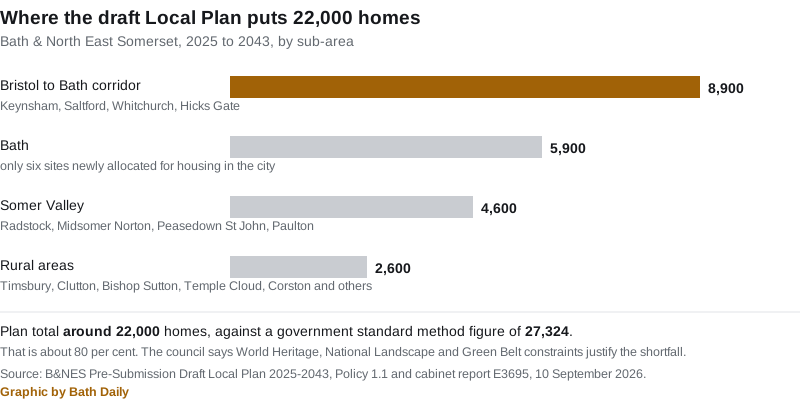
The Bristol to Bath corridor means Keynsham, Saltford, Whitchurch and Hicks Gate. It takes the largest share. The Somer Valley covers Radstock, Midsomer Norton, Westfield, Peasedown St John, Paulton and Farrington Gurney.
The largest allocated sites
These are the biggest site allocations in the draft, with the council’s indicative capacities. The plan is explicit that these figures are not a cap, and that a higher number may be supported at application stage.
| Site | Homes | Chapter |
|---|---|---|
| Hicks Gate | around 2,000 | Bristol to Bath corridor |
| North Keynsham | 1,450 to 1,700 | Bristol to Bath corridor |
| East Whitchurch Village | around 1,040 | Bristol to Bath corridor |
| West Saltford | around 960 | Bristol to Bath corridor |
| South West Keynsham | around 950 | Bristol to Bath corridor |
| North Radstock | around 950 | Somer Valley |
| South Peasedown | around 860 | Somer Valley |
| South-west Whitchurch Village | around 700 | Bristol to Bath corridor |
| Farrington Gurney South | around 500 | Somer Valley |
| West Keynsham | around 480 | Bristol to Bath corridor |
| South East Keynsham | around 390 | Bristol to Bath corridor |
| South Saltford | around 330 | Bristol to Bath corridor |
| West of Clutton | around 300 | Rural |
| Paulton South | around 300 | Somer Valley |
| Writhlington | around 300 in B&NES | Somer Valley |
Writhlington is the odd one. It is part of a strategic site of around 1,020 homes that crosses the boundary into Somerset, so only about 300 of those homes sit in this district. Its local centre would be built in Somerset, on or next to Frome Road.
Smaller allocations run down through the villages:
- West Bishop Sutton, 280
- East Timsbury, 240
- Timsbury Road, 200
- West Timsbury, 170
- Chilcompton Road, 160
- Haydon, 140
- North of Temple Cloud, 130
- Thicket Mead, 130
- Hedgehogs, 100
- East of Avon Mill Lane, 100
- Lower Peasedown, 80
- Farrington Road South, 70
- Land west of Corston Lane, 60
- North of Fox Fields, 50
- Devonport House, 50
North Keynsham is the one to read closely. Its policy requires:
- 40 per cent affordable housing
- a two-form entry primary school on site, with early years provision
- a local centre with a convenience shop, healthcare space and a community space
- a new road intended to take through traffic out of Keynsham town centre
- a minimum of 3.5 hectares of employment land
- money towards a 300-place expansion and a 170-place sixth form expansion at Wellsway School
- money towards a 300-place expansion at Lift Broadlands Academy
Green Belt land at nine settlements
Meeting the numbers means taking land out of the Green Belt. Policy 1.1 names where:
- strategic releases: Keynsham, Saltford, Whitchurch, Hicks Gate, Peasedown St John
- non-strategic releases: Batheaston, Chew Stoke, Corston, Farmborough
The council says the general extent of the Green Belt is retained, and that exceptional circumstances for release have been identified and justified in the evidence base. It also says the North Keynsham allocation boundary is deliberately larger than the area to be released, to keep open land between Keynsham and Saltford so the two stay separate places.
Only six new housing sites inside Bath
For all that Bath is credited with around 5,900 homes, the chapter on the city allocates just six sites as new housing:
- part of Kingswood School Playing Fields, around 90 homes
- Bath Equestrian Centre, around 40 homes
- land north of Napier Road, around 40 homes
- the car park adjacent to Combe Park, around 30 homes
- land east of Station Road, around 20 homes
- Julian Road, at the rear of St James’s Square, with no capacity published
The five with a published figure come to about 220 homes. Bath’s larger allocations, including Bath Quays North, Green Park Station West and the Lower Bristol Road group of sites, are mixed-use policies with employment floorspace figures rather than housing numbers. The Milsom Quarter masterplan carries an aspiration for about 180 homes, mostly by bringing empty upper floors back into use.
The one large greenfield option for the city has been dropped. Land west of Bath, considered for around 2,000 homes at the options stage, is not allocated. The council’s own landscape and historic environment assessment found development there would cause substantial harm to the World Heritage Site. The harm it identified was to what the plan calls “the green setting of the city in the hollow in the hills”, and it concluded that this could not be satisfactorily mitigated. The site may return in a future plan.
Keynsham takes the most
The plan sets a housing figure for each designated neighbourhood plan area. On that measure Keynsham is far and away the most affected place in the district:
| Neighbourhood area | New Local Plan allocations | Total requirement |
|---|---|---|
| Keynsham | 5,385 | 5,744 |
| Radstock | 1,318 | 1,387 |
| Farrington Gurney | 500 | 500 |
| Paulton | 392 | 472 |
| Midsomer Norton | 292 | 437 |
| Timsbury | 410 | 414 |
| Clutton | 330 | 330 |
| Stowey Sutton | 280 | 280 |
| Chew Valley | 120 | 120 |
| High Littleton and Hallatrow | 45 | 45 |
| Bathford | 30 | 30 |
Keynsham has just been through one of these. In August we reported on Persimmon’s 200-home scheme off Charlton Road, which drew 99 objections and two from Keynsham Town Council.
Below the government’s number, on purpose
The government’s standard method puts B&NES housing need at 1,518 homes a year, or 27,324 over the plan period. The draft plan provides for around 22,000, about 80 per cent of that.
The council’s case is that the district is too constrained to do more: Bath is a double inscribed World Heritage Site, there are two National Landscapes, and the Green Belt is extensive. National policy allows a lower figure where protected assets give a strong reason to restrict development.
The cabinet report is blunt about the risk. Setting a requirement below the standard method figure “is likely to be challenged by various stakeholders”, and there is a risk an inspector will not find the approach sound.
Delivery is also stepped, which matters for how easily speculative applications succeed:
| Period | Total homes | Annual requirement |
|---|---|---|
| 2025 to 2031/32 | 5,320 | about 760 a year |
| 2032/33 to 2042/43 | 16,698 | about 1,518 a year |
The 22,000 is made up of 772 completions in 2025-26, 5,042 existing commitments, 14,323 new allocations and 1,944 expected small windfall sites.
Across the sub-region the sums do not close. B&NES identifies unmet need of around 5,000 homes against the standard method. Bristol has identified unmet need of 13,860 homes to 2040. Together that is around 19,000 homes with nowhere allocated, to be picked up by the West of England Spatial Development Strategy, which is not due to be adopted until 2029.
What it means for you
The consultation is not another options exercise. Regulation 19 asks whether the plan is legally compliant and “sound”, meaning positively prepared, justified, effective and consistent with national policy. Comments that simply object to a site without arguing soundness carry much less weight. Everyone who makes a duly made objection has the right to have it considered by the inspectors.
The dates:
- consultation opens the week beginning 14 September 2026
- it closes on 26 October 2026
- the council must submit the plan for examination by 31 December 2026, or it cannot be examined at all under the current system
That deadline is why the 10 September decision is being taken as urgent. It is exempt from call-in under rule 3.2.30 of the council’s constitution. Normally a cabinet decision can be paused for scrutiny. This one cannot.
Where to raise it in person. The council has listed meetings in September and October with the Local Plan as the main item. Views still have to go through the formal consultation to count.
- 15 September, 5pm to 6pm, Bath Briefing, online via Microsoft Teams
- 16 September, 6pm to 7pm, Somer Valley Area Forum, online
- 21 September, 12pm to 1pm, Bath Briefing, online
- 22 September, 6pm to 7pm, Bathavon Area Forum, online
- 23 September, 6pm to 7.30pm, Chew Valley Area Forum, The Library, Chew Valley School, BS40 8QB
- 24 September, 6.30pm to 7.30pm, Keynsham Area Forum, Community Space, 5 Temple Street, BS31 1HA
- 21 October, 6.30pm to 8.30pm, Parish Liaison, Community Space, 5 Temple Street, BS31 1HA
Joining details for the online meetings are on the council’s area forums page, and the online meetings are recorded to the council’s YouTube channel.
If your home is near an allocation, the site policies are where the detail sits: access points, affordable housing percentage, school and healthcare contributions, and what has to be built before homes are occupied. The four sub-area chapters are published with the cabinet papers, split by Bath, the Bristol to Bath corridor, the Somer Valley and rural areas.
The plan preparation has already cost the council money it had to set aside. Up to £850,000 was approved from the Financial Planning Earmarked Reserve for 2025/26 and 2026/27, of which £321,537 was drawn down in 2025/26.
The report author is Richard Daone, Deputy Head of Planning.
Sources: Cabinet agenda, 10 September 2026; Pre-Submission Draft Local Plan 2025-2043, cabinet report; Chapter 1, District-wide Strategy; Chapter 2, Bath; Chapter 3, Bristol to Bath Corridor; Chapter 4, Somer Valley; Chapter 5, Rural; council announcement, 2 September 2026.
More local information: Bath planning news, Bath house prices, council tax bands.
Have your say